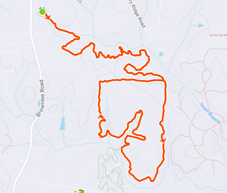
The Creeks Trail System • Town Branch to Aboothlacoosta Loop • ~8.8 miles • ~700ft elevation
Overview
This was the first Jackson trail run I hauled my butt around back in November 2024. I was shopping for/viewing homes in the area and simultaneously training for the Pine Mountain 40 miler, Heartbreaker 50 miler, and Hellbender 100 miler. I stumbled upon the Butts County Greenspace and Creeks Trail System while thumbing my way around on Google Maps and thought I could mix business (house tours) and pleasure/pain (training).
While the elevation gain is nothing to write home about (as one would expect from a middle-ish Georgia topography), I was blown away by how many miles of trails were available. I was moving from Atlanta where trails were limited but sidewalks were endless. I expected Jackson to be a regression to running on road shoulders and dodging unnecessarily large trucks. That obviously hasn’t been the case, and now I do about 75% of my running on trails, with the rest on gravel roads (or indoors on the treadmill).
Specs
- Distance: 8.8 miles
- Elevation Gain: ~700 ft. (No truly meaningful climbs).
- Terrain Breakdown: 100% singletrack
- Difficulty: Easy. Roots and rocks will be your biggest challenge.
- Ideal Gear: Nothing crazy—trail shoes and maybe 500mL of hydration.
Logistics & Resupply
- Parking/Start Point: Trailhead at 995 Brownlee Rd, Jackson, GA 30233
- Water & Fuel: Creek at ~3.5 miles; definitely need a filter.
- Cell Service: Good service at trailhead and decent service throughout the route; can be spotty when tree cover is seasonally thick.
- Bathrooms: Portapotty at the trailhead.
Breakdown
- The Approach (Miles 0 – 2.4): Parking lot to the Aboothlacoosta Loop; there used to be a cool little 1-hop creek crossing here, but it was completely filled in sometime in 2025.
- Aboothlacoosta Loopin’ (Miles 2.4 – 6.2): The main loop; mostly rolling. Water at mile 3.5 (take trail to Lake Clark Loop at intersection – stop at the bridge, refill, turn around, continue loopin’).
- Back Home (Miles 6.2 – End): The same thing as the first section, just in reverse.
GPX Route/File