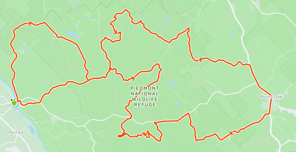
Piedmont National Wildlife Refuge • 45 miles • 3700 feet
Overview
A near-zero (automobile) traffic route that pairs every steep/fast descent with an equally steep/punchy climb. This route follows the Fried Green Tomato 50 course, an event previously hosted by Ocmulgee Mountain Bike Association (OMBA). I can’t find any indication they’re still organizing this ride annually, which is really too bad.
You could ride this on a mountain bike, but I chose my Parlee Chebacco gravel bike and felt fine. I didn’t encounter anything that made me second guess my choice, either. You could maybe even survive this on a durable road bike, if conditions were bone dry and you clairvoyantly picked perfect lines through the rough sections.
Specs
- Distance: 45 Miles
- Elevation Gain: 3700 ft. No super consistent climbs – lots of punchy, steep ascents out of creek crossings
- Terrain Breakdown: 90% Gravel / 10% Paved
- Difficulty: Medium-Hard. If things are wet, the climbs and descents feel hairy. If it’s dry, everything is probably still hard, just a little faster
- Ideal Gear: Gravel or mountain bike; water filter for refilling at creek crossings
Logistics & Resupply
- Parking/Start Point: Juliette Park – 5543 Juliette Rd, Juliette, GA 31046. A very informal park with a few picnic tables and grills. Parking is pretty much anywhere your vehicle fits
- Water & Fuel: Multiple opportunities to refill water at creek crossings with use of filter
- Cell Service: Spotty; download GPX/route on your app of choice and watch/cycling computer
- Bathrooms: No facilities; I think I saw a few porta potties on route where there were active forest clearing projects going on, but I wouldn’t count on those being available.
Breakdown
- Entering the Refuge (Miles 0 – 5): Easy miles from Juliette Park, into the Refuge, and over some well-traveled gravel
- First Real Miles (Miles 5 – 10.6): Two creek crossings complete with steep descents and punchy climbs. Some washed out gravel and mud. Get used to this.
- Little Rock and Pippin (Miles 10.6 – 21.8): Two tough gravel sections separated by a brief 1.5 mile paved road reprieve. More creek crossings.
- Smooth way, rough way (Miles 21.8- 36): A little over 2 miles of paved road riding before returning to your gravel reality. More of the same features you’ve been experiencing all day.
- Juliette Road back home (Miles 36 – 45): A little overlap here with the beginning of the ride, but a quick turn onto 3 Loop Road gets you over to new gravel on Juliette Road and a challenging final climb before the descent (starting at mile ~42) back to the park.
GPX Route/File